

ATLANTIC & PACIFIC HURRICANE ACTIVITY & PREDICTIONS 2014
Predictions for the 2014 North Pacific
Hurricane Season
Monday May 05, 2014
In the late afternoon sky I saw what looked like a large feather in the sky and it reminded me of a quilt pen. Later I saw swirling clouds and a circle in the centre of the sky. The feather is indicating that it's time to prepare and start taking notes and the ring around the swirling clouds suggests the activity is starting up with the hurricane season. It won't be too long before we see our first storm of 2014.
Tuesday May 06, 2014
In the evening I looked up NOAA's National Hurricane Center site and saw that the first low pressure area of the season for the Pacific side has been spotted. Thus hurricane activity in the Pacific side is starting to heat up for the 2014 season.
Friday May 23, 2014
Mexico get ready to meet Amanda. The first tropical storm of the season has formed today and it's presently headed in a WNW direction but will turn northward and then back towards land as it gets caught up in the trade winds and currents. Amanda plans to visit an area around where Manuel hit last year.
Saturday May 24, 2014
Today I came to realize that Amanda will be a strong storm while out at sea. NOAA's early predictions has her stalled out at sea and ending up there but I still believe she will later head towards Mexico to the area visited by Manuel last year even if only as a post-tropical depression.
Monday June 02, 2014
In the afternoon the second tropical depression, Two-E, formed south of southeastern Mexico. I am calling him Precursor because he is a sign of things to come for the season - much rain will come with various systems including the main event scheduled for late September into October. See Outlook.
Two-E will soon become Tropical Storm Boris and I expect him to traverse across the isthmus over to the Bay of Campeche on the Gulf side where he will interact with the low-pressure system situated there.
Saturday June 07, 2014
This morning from dreams and observations I came to realize that 94E in the Pacific will become tropical cyclone Cristina. She will traverse paralleling Mexico's coastline affecting areas up towards Puerto Vallerta before heading out to sea bringing heavy rainfall to some areas.
Tuesday June 17, 2014
NOAA is observing an area associated with Tropical Wave 3 but I feel that this will not amount to development of a cyclone.
Saturday June 21, 2014
Had a dream last night and from it was shown that 95E will struggle trying to become a cyclone and in the end will fail.
Friday June 27, 2014
Dreamed last night about water coming in the house and the basement had some flooding. Also there was a wash sink I was looking at. Came to realize this meant that twin storms will form and one will be closer to land than the other.
Saturday June 28, 2014
Also dreamed of opening a box that was empty because its contents were moved. Then realized that an area being watched won't become a depression until July, it's date moved from June into July. This dream pertains to the formation of Arthur in the Atlantic whereas the one from June 27 are the twin storms to come, Douglas and Elida in the Pacific.
Friday July 11, 2014
Many times I can break down or group events based on strong seismic-quakes in the earth. Two sets of twins are to form next based on what I saw back on June 30. I was looking at the earthquake activity that day and saw three parallel sets of quakes that have occurred in the past week. Between the first and second set was one quake by itself. What this is showing is that Douglas and Elida will be followed by Fausto on its own. Now that these three have come and gone there will be two sets of twins forming, first, Genevieve and Hernan followed by Iselle and Julio.
Monday July 14, 2014
I came to realize today that the July 16 date I was given is pertaining to the Western Pacific and not the eastern portion. All is quiet in the eastern North Pacific and the North Atlantic and all eyes should be on the western Pacific. Typhoon Rammasun will move across the Philippines on the 16th.
Thursday July 17, 2014
Typhoon Rammasun has crossed over the Philippines but behind it are four more potential areas for storm formation. Could it be that my next set of twins is referring to 93W becoming Matmo, right behind Rammasun? If so then 94W, 95W and 96W will not form, otherwise this could not be labelled as twins.
Saturday July 19, 2014
Now that the July 16 prophetic date was fulfilled by Rammasun crossing the Philippines, the next date to take note of is July 23. This will be back in the eastern half of the North Pacific basin.
Friday August 01, 2014
Back on July 7 I mentioned August 6,7 and 8 are important dates. This is when Typhoon Halong (Jose) will be impacting the western Pacific island region and making landfall on the 8th. Today's graphs show him to be headed towards South Korea and Japan. However, I sense it will be a more direct hit on Japan.
Monday August 04, 2014
Hawaii is being threatened by two tropical cyclones only days apart. But only one should make landfall. Also, this current round of activity will end on August 16 with Julio becoming a post-tropical depression.
Tuesday August 12, 2014
Realized today that the next phase will be much quieter than the one that just ended. So far see three storms forming for the Pacifc basin.
Sunday August 31, 2014
As the month of August winds down its quiet once again in the Pacific basin. But September will see a cyclone going up the Pacific coastline of Mexico and then towards the end of the month will be a large system bringing much rain to Central America and parts of Mexico.
Tuesday September 02, 2014
The fact that Norbert is about to go up the Pacifc coast in the coming days has me concerned. Not about how Norbert may affect the coastline but of what the mid-September event will be doing to this area. I was given the dates of September 16 - 17 for a cyclone to go up the Pacific coast. The fact that this cyclone is doing just that, though I had no insight in regards to this, has me worrying about the one that will be coming up along a similar path in the days to come. Furthermore, since the female-named systems are the stronger ones this year, and presenlty we have a male-named cyclone, Norbert, if a female system does form in time for the middle of the month to traverse this area she will be a much bigger story.
Wednesday, September 10, 2014
Tropical Storm Odile formed today and my feelings on it is that she is going to be stronger than Norbert and she will move much closer to land than Norbert. So get ready for some wet and windy conditions further north.
Thursday, September 25, 2014
Tropical Storm Rachel has formed and she is staying away from the mainland. But all is not as calm as it seems. Things are about to be stirred up and next week will be a wet week for Central America.
__________________________________________________________________________________
For the latest updates in the Pacific basin click on the Pacific Activity button.
For predictions concerning events in the North Atlantic basin click on the
Atlantic Predictions button.
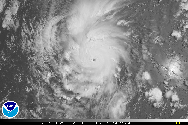
Major Hurricane Amanda on May 25, 2014. At her peak intensity sustained winds were at 155 mph making her the strongest May cylcone ever recorded.

Boris was responsible for setting off a mudslide in a mountainous region of Guatemala that killed five people as well as causing hot lava debris to flow in mudslides in a river near an active volcano.

The above satellite imagery shows what looks like raised handles on a faucet. Shortly after this photo was taken Tropical Depression Four-E (later Douglas) formed followed by Elida less than 48 hours later.

Super Typhoon Rammasun, "Thunder God" on its way to the Vietnam-China border after crossing over the Philippines.

Typhoon Halong (Jose) is projected to be headed to the Korean peninsula and Japan. I hope people will be receiving plenty of advanced warnings.

Three storms hightlighting this phase of the tropical cyclone season - Tropical Storm Karina, Tropical Storm Lowell and Tropical Storm Marie.

Oh dear - it's Major Hurricane Odile just hours before coming ashore near Cabo San Lucas, California Sur. Image taken September 14 at 1755 UTC (1055 PDT)