

ATLANTIC & PACIFIC HURRICANE ACTIVITY & PREDICTIONS 2014
Predictions for the 2014 North Atlantic Hurricane Season
Thursday May 15, 2014
Last year's hurricane season ended up being below-average in activity even though at the onset most people were calling for an above-average active season. I was one of the few who called for a below-average active season.
For the 2014 North Atlantic Tropical Cyclone (Hurricane) Season early forecasts or outlooks are hinting at a closer to normal or average hurricane season (see North Atlantic Outlook). I am still trying to assess the movement of ocean currents and winds and the effect of any El Niño oscillations that may emerge. My feeling is that this year's North Atlantic Hurricane Season will see similar results when compared with last year's events. Last year we had 14 cylcones of which 13 became named storms and 2 of these became hurricanes. Neither one was a major hurricane.
For the 2014 North Atlantic Tropical Cyclone Season my official prediction is for 13 - 15 cyclones of which 12 - 14 will become named storms or cyclones. Of these only 2 - 4 will acquire hurricane status (wind speeds ≥ 74 mph, 119 km/h) and we may have one major, or again see no major hurricanes (wind speeds ≥ 111 mph, 178 km/h).
Friday June 06, 2014
A low pressure system in the Atlantic, 90L, becomes well defined before crossing over land near Vera Cruz, Mexico. Even though it never became a cyclone I am labelling him as 'Struggle' because he represents the type of season the Atlantic basin will face this year - cyclones struggling to form and keep up with last year's, albiet, low numbers.
Tuesday June 24, 2014
The North Atlantic hurricane season is off to a slow start and no activity until July. But that doesn't mean things won't begin to happen soon. For the Atlantic-side two of the tropical cyclone events to keep an eye on will be the ones named Bertha and Edouard.
Saturday June 28, 2014
In dreams yesterday one was about going to open a rectangular box which turned out to be empty but realized someone moved the contents. Today I realized that the dream is pertaining to the coming storm Arthur. Arthur's birthdate, becoming a tropical cyclone, 'has been moved' from the end of June to the beginning of July.
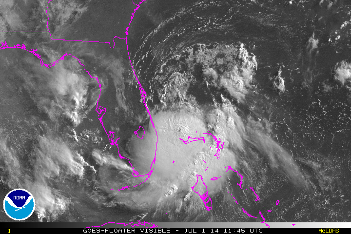
Tuesday July 01, 2014
Today is Canada Day and I had a dream earlier this morning involving the newly formed Tropical Depression - One in the Atlantic. From the dream I came to realize that this depression will evolve into a Hurricane and intensify into a Category 2 before crossing over the land masses. It will also be affecting the eastern US coastal area in time for their celebrations for the July 4 long-weekend. Furthermore Arthur will finally cross over both Nova Scotia and Newfoundland in the maritimes.
Monday July 07, 2014
Now that Hurricane Arthur has left his mark everything will be quiet until Bertha comes along. Take note of this one because she will be making waves.
Sunday July 27, 2014
In the evening I saw a storm form along with a funnel cloud and was shown this is to be Bertha. I am calling her Big Bertha because she will have a big impact. And if you're wondering where she is right now, look at the tropical wave southwest of the Cape Verde Islands.
August 14, 2014
Both NOAA and I spotted an area of interest off the African west coast today. NOAA stated that conditions are unfavourable for cyclone formation at present. That's true for now but from what I am seeing I expect it to take shape as he is closer to or in the Caribbean waters, much the same as what Bertha did.
August 31, 2014
The month of August is winding down and September is coming. In September we will be seeing a cyclone forming on the 10th as well as a larger one coming on the 26th. The first cyclone will be staying more in the middle of the Atlantic whereas the latter one will be moving from the mid-Atlantic over towards the North American east coast.
If you are wondering where the next set of cyclones will come from then keep an eye on Africa becasue these two systems mentioned will be originating from off the west coast of Africa.
__________________________________________________________________________
For the latest updates in the Atlantic basin click on the Atlantic Activity button.
For predictions made concerning events in the eastern North Pacific basin
click on the Pacific Predictions button.

2013 Atlantic Storms

Low pressure 90L
Tropical Depresson - One

96L - soon to be named Cristobal - the unicyclist

Tropical Depression Six captured by NOAA's GOES east satellite on September 11 at 0745 EDT