

ATLANTIC & PACIFIC HURRICANE ACTIVITY & PREDICTIONS 2014

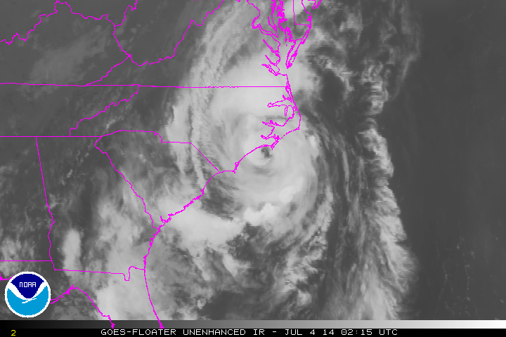
July 04 - Outer Banks, North Carolina

July 01 - Canada Day dream

Third
Time's
a Hit

Tropical Storm Arthur forms July 01 at 1100 EDT (1500 UTC)
Personal Insights
Observations
Arthur is the first named storm and first hurricane of the Atlantic tropical cyclone season. He is on record for being the earliest one in any season to make landfall in North Carolina. Click on the images below to see how Arthur affected the Outer Banks of North Carolina and the Maritime Provinces.

Arthur - first tropical cyclone ever to hit the US on Independence Day
Recap of Arthur Category 2 Hurricane
June 30 to July 06


I had a dream in which I was surveying an area with an island in the middle and water all around, all on some platform or stage. I saw water spilling in one area so went to make repairs to the foundation underneath. The water was not your typical shades of blue (sorry I didn't put it in my drawing), instead it was coloured red and white. Then I saw a blue-coloured fish and a grey shark and then a bigger grey shark which tried to swallow me but then spit me out. The fish were all swimming together in one direction. It seemed that the bigger shark tried to swallow the smaller one when on the far side of the island, out of my view, and then when in front of the island, but spit me out again.
Interpretation of the dream: Tropical Depression forms off the southeastern US coast and 12 hours later becomes Tropical Storm Arthur - the blue-coloured fish. Two days later Arthur becomes a Hurricane - the smaller grey shark. 16 hours later he becomes a Category 2 Hurricane - the bigger grey shark. As a Category 2 Arthur makes landfall at night at the Outer Banks, NC - swallowed behind land, and finally makes a second landfall in the morning hours on the southwest coastal area of Nova Scotia - swallowing the second time and also why two circles around the island. First landfall is in warmer waters and the second landfall is in much cooler waters - the red and white colours of the water in the dream.
Since June 27 NOAA has been tracking an area of low pressure over South Carolina which eventually moves offshore and later helps to form Tropical Depression-One on June 30 around 11 pm. 12 hours later TD-One becomes Tropical Storm Arthur and heads up the US eastern coastline strengthening into a Category 2 Hurricane before making his first landfall over the Outer Banks, North Carolina 72 hours after becoming a depression.
From the National Hurricane Center storm archives
This is the third time that an Atlantic cyclone named Arthur has threatened the North Carolina coast. Shown here are the three storms: Tropical Storm Arthur on June 19, 1996 from GOES-8; Tropical Storm Arthur on July 14, 2002 from GOES-8; Hurricane Arthur on July 3, 2014 from GOES-13. Then on July 03 at 1115 pm EDT (July 04 0315 UTC) Hurricane Arthur makes landfall over the Shackleford Banks between Cape Lookout and Beaufort, North Carolina.
Hurricane Arthur started from a low pressure area that formed off the southeastern US coast on June 30 and became a Category 2 Hurricane before its first landfall on July 3. He continued towards the Canadian Maritme provinces were he made landfall July 5 in the Digby County area of Nova Scotia. Click image above to view Arthur's time-line.


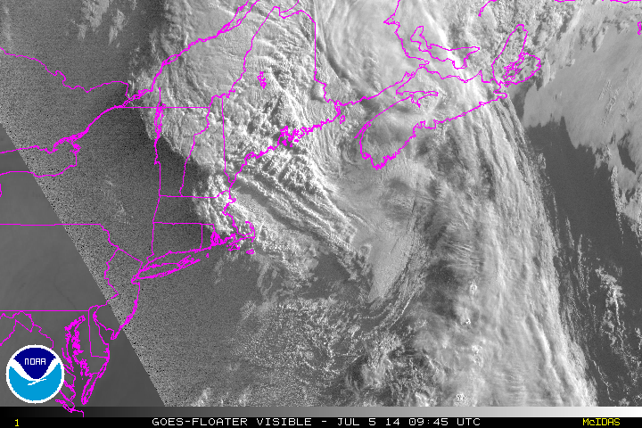
Outer Banks, North Carolina The Maritime Provinces
NOAA's Geostationary Operational Environmental Satellite called GOES-East continually monitors the Atlantic Ocean and data was used to create this animation showing the first Atlantic Ocean tropical cyclone from birth to death. The GOES-East movie shows Hurricane Arthur from June 28 to July 4, 2014.
The Canadian Hurricane Centre (CHC) in Dartmouth, Nova Scotia issued a special meteorological summary for post-tropical storm Arthur. Click image below to read their article.


Hurricane Arthur hits Frost Park in Yarmouth, Nova Scotia. Video by Shawn Bourque, July 05, 2014