

ATLANTIC & PACIFIC HURRICANE ACTIVITY & PREDICTIONS 2014

June 13 at
2300 EDT
(2000 PDT)
June 07 at
0815 EDT
(0515 PDT)
Cristina becomes the earliest second Category 4 Hurricane on record

Tropical Depression
03-E forms in the eastern North Pacific basin
Personal Insights
Observations

Second Major Hurricane Cristina - June record breaker


Recap of Major Hurricane Cristina June 09 - 16
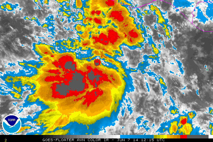
In the early morning hours of June 07 I had a dream of seeing cars backed up on a road. I was in another car on the right shoulder of this road and we backed up because couldn't go forward, only to find ourselves coming up to an opening or crack in the earth. Next thing I knew we were next to a cliff with only inches between the car and the rocks. At 7:55 I checked for an earthquake I knew took place a few days ago and found it to be SW of Puerto Vallerta, Mexico. In summary the dream is indicating a tropical cyclone will traverse between a fault zone in the earth on its right and cliffs of a coastline on its left. Affects of the hurricane will cause traffic chaos. So I look up the GOES satellite imagery and find this interesting image (see photo above). Shortly afterwards NOAA marks it as an area of interest.
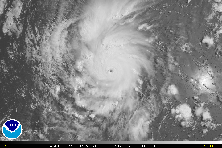
On June 13 at 0800 hrs PDT (1100 hrs EDT) Hurricane Cristina attains her maximum wind speed of 150 mph, 240 km/h and is heading in a WNW direction towards the Socorro Island. Her path is paralleling the Rivera Fracture Zone on her right and by 2000 hrs PDT (2300 hrs EDT) she passes to the east of the island with the eye only 20 miles, 35 km off on her left. Hurricane force winds extend up to 25 miles, 40 km. The map above shows the locations of Hurricane Cristina on June 12 at 2 pm and June 13 at 11 am. I don't mark where she passes Socorro Island because it is right next to the island and would cover the island's location. The Mexican coast felt effects of cyclone Cristina as she traversed the area these past four days. Thankfully no fatalites were reported though one female crocodile was injured.
From 5 am on June 07 to 5 pm of the same day NOAA has increased the probability of a low pressure area located several hundred miles south of Acapulco, Mexico of becoming a cyclone from 10% over 48 hours to 40% over 48 hours. By 2 pm on June 09 Tropical Depression Three-E forms and by 8 pm that same day becomes Tropical Storm Cristina. Finally by 2 am on June 11 the cyclone becomes the second Hurricane in the east Pacific.
24 hours after becoming a hurricane Cristina becomes a Major Category 3 with winds of 120 mph, 195 km/h. Three hours later she becomes a Category 4 Hurricane. Then by 8 am Cristina reaches her max with sustained winds of 150 mph, 240 km/h. This feat marks the first time there's been two category 4 hurricanes in the month of June for the eastern North Pacific basin since satellite data records were introduced in 1966.
Cristina was a powerful Category 4 hurricane at her peak and the fact that she stayed a good distance from the Mexican coastline meant minimal affect to land and people's lives and possessions.
Click image below for highlights of Cristina


