

ATLANTIC & PACIFIC HURRICANE ACTIVITY & PREDICTIONS 2014

The Event - August 25 at 1415 EDT (1815 UTC)

The Sign - August 25 at 1255 EDT (1655 UTC)

About to move over land on Sept 02 at 2315 UTC

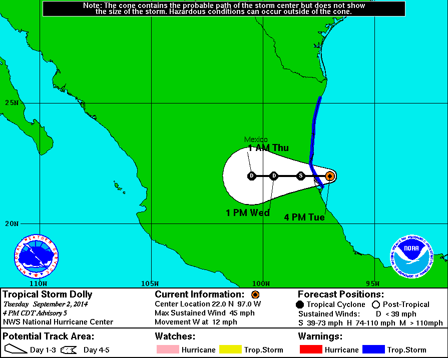
Tropical Storm Dolly on Sept 02 at 1245 UTC
Personal Insights
Observations
Heavy rains and flash floods, and potential for mudslides had classes cancelled and schools closed in many parts of Mexico along the Gulf coast. Click on the image above to read a related article.

Tropical Depression 5 later named Dolly
in the Bay of Campeche on September 01
Dolly short lived but still made an impact
On August 25 at the noon hour I was out on my balcony watching the clouds go by and then this one particular formation caught my eye. It had a nice square shape to it, see image above. So I took photos of this formation over the next few minutes which changed in shape; first showed a rectangular or square area, then a circular area and finally a storm area. These are indicating that an area currently under observation is going to become the next cyclone. Look at 97L 0825-1815 the same square!!!
Shortly afterwards I was looking at the satellite images that NOAA was collecting and there was the square in the water just like the square I saw in the cloud formation. So I knew at this point that the next Atlantic cyclone will be emerging from this area. Interestingly enough is the fact that a square has four sides or four points. So this 'square' in the sky is 'pointing' to the 'fourth' named storm in the waters of the North Atlantic tropical cyclone season.
NOAA was monitoring a tropical wave more than 1200 miles east of the Lesser Antilles since August 24. The area was producing disorganized showers and thunderstorms and as it continued to move westward in the following days NOAA was increasing its chance of becoming a tropical cyclone. On September 01 the area is deemed to be a tropical depression and nine hours later is declared to have been transformed into Tropical Storm Dolly the fifth cylcone and the fourth named storm of the North Atlantic hurricane season.
Tropical Storm Dolly reaches maximum sustained winds of 50 mph during its short-lived life cycle and 30 hours after first being declared a depression, the center of Dolly moves ashore, 25 miles SSE of Tampico, Mexico with 45 mph sustained winds bringing much rain to the area. Dolly dissipates 12 hours later about 90 miles WSW of Tampico but the system continues to pound heavy rains over a wide area.


NOAA's Geostationary Operational Environmental Satellite called GOES-East continually monitors the Atlantic Ocean and data was used to create this animation showing the first Atlantic Ocean tropical cyclone from birth to death. The GOES-East movie shows Hurricane Arthur from June 28 to July 4, 2014.
Tropical Storm Dolly at its peak intensity on September 02 at 1730 UTC with 50 mph winds. NASA LANCE-MODIS satellite imagery
