

ATLANTIC & PACIFIC HURRICANE ACTIVITY & PREDICTIONS 2014

June 29 at 2300 EDT (2000 PDT) to June 30 at 1100 EDT (0800 PDT)

June 28 at 1315 EDT
(1015 PDT)

Tropical Storm Elida
June 30 - July 02

Tropical Storm Douglas
June 28 - July 05
Personal Insights
Observations
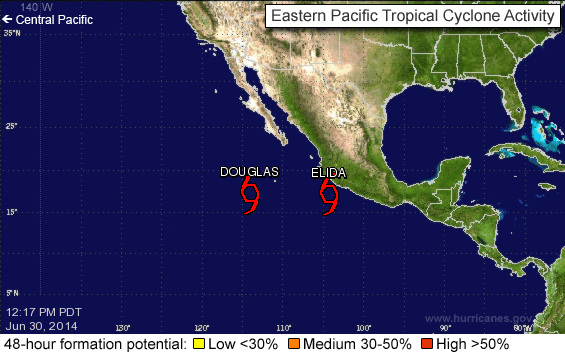
Douglas and Elida the first set of Pacific twins


On June 27 I had a dream in which I was standing next to a wash basin and noticed water coming down along the wall in front of me because of the rain that is going on outside. I realized it was also going down into the basement below but I didn't want to check there because I knew it would be worse down there than up on the main floor. Then on the 28th I saw the satellite photo shown above and realized that the dream was telling me that two cyclones will come out of this system, one next to the other and the first one to form will have less of a 'water' impact on land than the second one. The cloud formations look like a sink faucet with two handles on either side, just like in the dream.
Tropical Storm Douglas formed on June 29 at 8 pm local time and 12 hours later at 8 am on June 30 Tropical Storm Elida formed. At this point in time the centre of the two cyclones were approximately 1072 km apart. But Elida was closer to the Mexican coastal area and therefore had a greater effect on bringing rain to the land - as was illustrated by the dream I had.
These two storms formed in close proximity to one another and also close in time. During this phase of the hurricane season you can expect to see more of the same to happen in the eastern North Pacific basin.
On June 23, the NHC began highlighting the potential for a tropical cyclone to develop south of Mexico several days out. A large area of shower and thunderstorm activity developed on June 25, leading to the formation of a broad area of low pressure two days later. Steered west-northwest by a mid-level ridge to the north, the disturbance steadily organized over warm water and in a low wind shear environment and acquired sufficient organization to be declared a tropical depression by 2100 UTC on June 28. At 0300 UTC on June 30, it was upgraded to Tropical Storm Douglas. Later on 30 June, Douglas attained its peak intensity of 45 mph, but the NHC noted that this operational estimate could possibly be slightly low. As a result of dry air infiltrating Douglas' circulation and Douglas traversing cooler waters, its maximum sustained winds decreased to 40 mph on 2 July. The unfavorable conditions slowly but surely took their toll on Douglas, and it weakened to a tropical depression during the early morning hours of 5 July. At 11:00 Eastern Time the same day, Douglas was declared a post-tropical cyclone as it had lost all of its deep convention and its center of circulation was fully exposed.
The NHC began monitoring a large area of disorganized showers south of Central America on June 27 as it tracked generally west-northwestward. Despite unfavorable upper-level winds as a result of its proximity to nearby Tropical Storm Douglas, convection associated with the disturbance steadily increased over the coming days, resulting in the designation of Tropical Storm Elida by 1500 UTC on June 30. Initially, moderate to strong wind shear was expected to decrease in subsequent days, allowing for some intensification of the cyclone; however, this did not occur and Elida began to weaken instead as the low-level center became decoupled from the deep convection. After being devoid of thunderstorms for over 12 hours, the system was declared as a post-tropical cyclone by 0900 UTC on July 2.

Douglas July 01 at 2100 UTC Elida June 30 at 2320 UTC
