

ATLANTIC & PACIFIC HURRICANE ACTIVITY & PREDICTIONS 2014
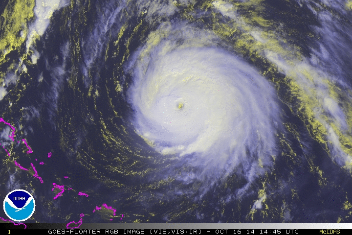
Maximum winds were recorded at 145 mph on October 16

Hurricane Gonzalo
(PART I)
October 12 thru 19
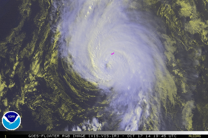
Oct 17
at 1945 UTC
Bermuda
bound

Tropical Storm Gonzalo forms as Tropical Storm Fay brushes past Bermuda
Personal Insights
Observations
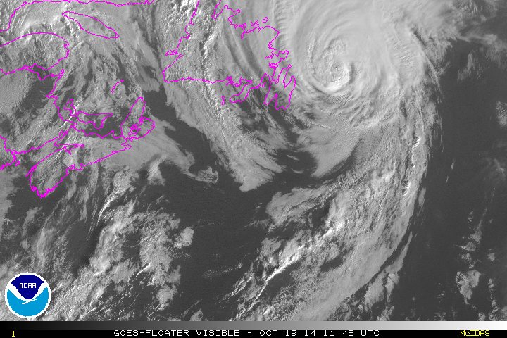
Gonzalo continued moving north-northeastward after going over Bermuda and was picking up speed along the way. Late Saturday and early Sunday, October 18-19 Gonzalo passes near Newfoundland bringing heavy rains to parts of the island. The artcle below highlights Gonzalo's effect on the Canadian Province.
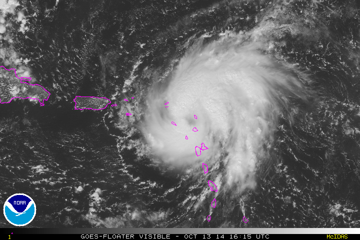
Tropical Storm Gonzalo on October 13 seen passing by, not over, Puerto Rico


Saturday May 24, 2014
Four and a half months before the event, I was told that October 16th was a date to keep in mind. Around this time will be a system that will be forming south of Cuba? and then moving north, by or past Cuba. The question mark by Cuba is because of the uncertainty if it was Cuba that was earmarked or one of the other large Caribbean islands. We have four large islands grouped together, Cuba, Jamaica, Hispaniola and Puerto Rico. Due to the uncertainty i decided to look at these collectively and refer to a storm starting somewhere below these islands and then coming up northwards but bypassing them.
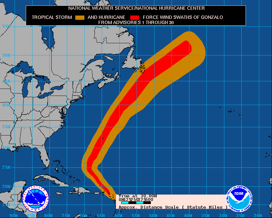
Gonzalo became a storm on October 12 just east of the northern Lesser Antilles and was first expected to move over the Virgin Islands and possibly Puerto Rico. But the cyclone bypassed this area on the 13th and 14th all the while gaining strength. Because it did not go over Puerto Rico the system was able to strenghten quickly and became a hurricane on the 13th while about 20 miles SE of St. Martin. Gonzalo then became a major hurricane on October 14 and on the following day, the first Category 4 Hurricane since 2011. He topped out at maximum sustained winds of 145 mph, 230 km/h.
After reaching maximum strength Gonzalo begins to weaken a bit. Just before hitting Bermuda around 2000 hrs EDT on October 17 the cyclone is downgraded to a Category 2 Hurricane with winds of 110 mph, 175 km/h. Five days after Tropical Storm Fay passed over Bermuda the northern portion of Gonzalo's large eye moved over the small British territory. Gonzalo continued on his path with hurricane
force approaching the Avalon Peninsula late on October 18 as a strong category 1 hurricane and maintained this intensity as it passed about 32 miles, 50 km south of Cape Race, at the southeastern tip of Newfoundland, in the early morning hours of October 19.


Bermuda is hit by Hurricane Gonzalo on Friday, October 17, 2014 but fortunately no deaths are reported. Above video shows the swells caused by the storm over the island territory.
The energy from the remnants of Gonzalo not only reach the United Kingdom adn western Europe but makes it across the continental Europe all the way to Greece where flooding occurs in Athens. see below


The remnants of Hurricane Gonzalo had a major impact across parts of Europe. The above video highlights the flooding it produced in Athens, Greece.
With the name of Gonzalo and seeing how the male-named Atlantic cyclones were all powerful this season I sensed that Gonzalo is going to be quite strong.
On October 12 Tropical Storm Gonzalo formed 200 miles east of Guadeloupe. Over the course of the next two days, October 13 and 14, Gonzalo passes well east of Puerto Rico while moving in a northwesterly direction. All this time Gonzalo is slowing gaining strength and by 1700 hrs EDT on the 14th he becomes a major hurricane. Gonzalo fluctuates in intensity over the course of the next day but then reaches maximum wind speeds on the date given, October 16th, with sustained winds of 145 mph, 230 km/h.
A first hand account is given on Gonzalo's impact over Bermuda as the system moves up the eastern coastline. Click on image below to read the article.
PART II - Energy of Gonzalo crosses the Atlantic - October 19 to 26
After passing by Newfoundland, Gonzalo races across the Atlantic bringint rain to the UK and snow to the Alpine regions of Europe. see article below