

ATLANTIC & PACIFIC HURRICANE ACTIVITY & PREDICTIONS 2014

As I looked at this cloud formation in it I saw Hernan being content at sea

Hernan's track from July 24 to 29 as he moved 'happily' in open water

Who's next in this active part of the Pacific basin?
Personal Insights
Observations

Tropical Depression Eight-E forms in the early morning hours of July 26 and becomes Tropical Storm Hernan twelve hours later.
Tropical Depression 8-E formed on July 26 at 0200 PDT (0500 EDT or 0900 UTC). He was far enough away from land that he didn't pose any real threat to the coastal areas.
On Sunday I went to church in the morning and coming home after lunch I took this photo image of the clouds in the sky at 1341 hrs which is 1041 PDT. It gave me the impression that Tropical Storm Hernan wants to flex his muscles just a bit so he can stretch out and feel happy or content. Four minutes after taking this shot the same cloud formation was all closed up as if Hernan folded up his arms to relax. So from this I knew that Hernan was to become a Hurricane, even if only a short-lived one and so I nick-named him Happy Hernan.
On July 23 NOAA was already expecting an area of low pressure to possibly form over the next few days south-southwest off the coast of Mexico in an area were several other potential zones existed. In the above image item number 2 is the area that pertains to the genesis of the next tropical cyclone, Hernan.
So far, we have had one hurricane form in the month of May, one in the month of June, and Hernan goes on to become the only hurricane for the month of July.
On July 26 at 0200 PDT Tropical Depression 8-E forms about 410 miles (660 km) SSW of Manzanillo, Mexico. Twelve hours later it becomes Tropical Storm Hernan. Twenty four hours later on July 27 Hernan becomes the third hurricane in the eastern North Pacific as it passes Socorro Island around 1400 PDT. The following morning at 0200 Hernan begins to enter colder waters and 24 hours later is back to being a storm; becoming a remnant low shortly afterwards.
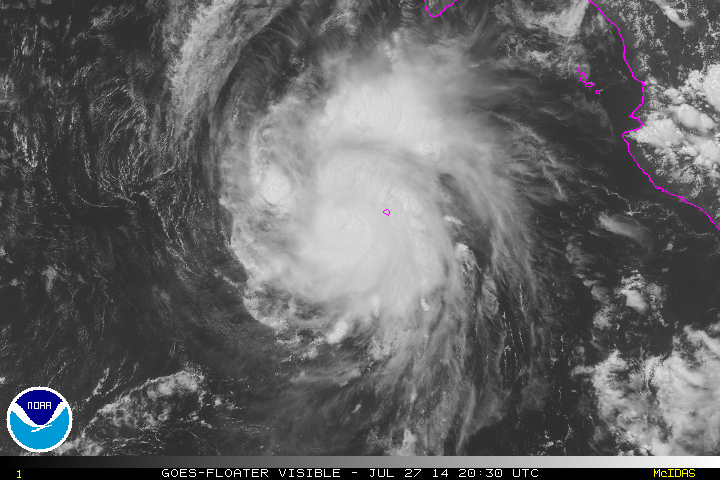
July 27 at 1330 PDT(2030 UTC)
West of Socorro Island
On July 27 at 2100 UTC (2 p.m. PDT) NOAA reports that Hernan is now a Category One Hurricane with winds of 75 mph, 120 km/h as it passes just west of Socorro Island. Credit: NASA/NOAA GOES Project